
Making Plate Tectonics Visible: An Inquiry-Based Modeling Approach

Why Plate Tectonics Trips Students Up?
Plate tectonics can be challenging to teach because much of what we want students to understand is invisible. Students cannot watch a tectonic plate move across the seafloor, observe mantle processes directly, or experience the movement of continents across 250 million years. They may learn to identify convergent, divergent, and transform boundaries, yet still struggle to explain what happens at those boundaries or connect individual processes into a larger story about how Earth changes.
I encountered this challenge repeatedly while teaching introductory physical geography to pre-service secondary teachers. Students could often identify tectonic features on a diagram, but explaining how and why those features formed was more difficult. Some students treated plate boundaries as narrow lines rather than dynamic zones of interaction. Others imagined magma as a continuous layer beneath Earth's surface or viewed continental movement as a series of sudden events rather than a continuous process operating over geologic time. These observations are consistent with research documenting persistent alternative conceptions about plate tectonics among undergraduate students (Clark et al., 2011; Dahl et al., 2005; Libarkin & Anderson, 2005).
I wanted students to move beyond recognizing labels on a diagram and toward explaining how, why, and over what timescale tectonic processes occur. I therefore developed a six-class instructional sequence built around three phases: Elicit, Explore, and Model. Students first make their existing ideas visible, then investigate tectonic processes using interactive visualizations and formative questions, and finally apply what they have learned by constructing a model of how Earth's continents might change over geologic time.
The culminating activity, creating a stop-motion model of a possible future Pangea Ultima, became the centerpiece of the sequence. Rather than asking students simply to memorize plate-boundary types, the activity asks them to use evidence about plate motion to construct, communicate, and revise a model of Earth's changing surface. The stop-motion format also gives instructors a window into student thinking: the way students move a continent, represent a plate interaction, or explain a geological feature can reveal ideas that may remain hidden during a traditional lecture or written assessment.
In the sections that follow, I describe how we used the Elicit → Explore → Model sequence, what happened when I implemented it in my classroom, and what I would recommend to instructors who want to adapt the approach for their own students.
A Different Approach: Elicit → Explore → Model
I originally developed this six-class sequence for an introductory physical geography course at a public university in the Midwestern United States. The course primarily served pre-service secondary education majors and combined lecture, laboratory activities, collaborative inquiry, visualization, and formative assessment. Although the sequence was developed for undergraduate students, its individual components can be adapted for introductory geoscience courses, dual-enrollment programs, and high school Earth science classrooms.
The sequence is organized around three connected phases: Elicit, Explore, and Model. Students first make their existing ideas visible, then investigate tectonic processes through interactive visualization and guided inquiry, and finally, use what they have learned to construct and explain a model of Earth's changing surface.
Elicit
We begin by finding out what students already think they know. Rather than assuming that students enter the unit with a blank slate, I use questions, ConcepTests (McConnell et al. (2006), and visual prompts to surface their existing explanations of plate motion and tectonic processes. These initial responses give me a starting point for instruction and provide students with ideas they can revisit as their understanding develops.
Explore
Next, students investigate the processes underlying the patterns they observed. Interactive visualizations, guided questions, discussion, and short case studies allow students to examine plate boundaries, earthquakes, volcanoes, mountain formation, and other tectonic processes from multiple perspectives. The emphasis is on asking students to explain what they observe and use evidence to support their explanations rather than simply memorizing categories of plate boundaries.
Model
Finally, students apply their developing understanding by constructing and explaining a model of Earth's changing surface. The culminating activity asks students to create a stop-motion simulation showing how the continents might move over geologic time and eventually form one possible future supercontinent, Pangea Ultima.
The purpose of the sequence is not to "fix" every misconception students may hold about plate tectonics. Instead, it is to provide repeated opportunities for students to make their thinking visible, examine evidence, test their explanations, and revise their models. The three phases work together: Elicit makes students' starting ideas visible, Explore gives them evidence with which to examine those ideas, and Model asks them to apply and communicate their developing understanding.
The complete sequence takes approximately six class sessions, but instructors do not need to adopt the entire unit. Individual activities can be used independently or incorporated into an existing plate-tectonics unit depending on available time, course level, and instructional goals.
The Unit at a Glance
The six-class sequence moves students from making their initial ideas visible to investigating evidence and ultimately applying what they have learned in a systems model.
Table 1. Unit at a Glance
|
Phase |
Sessions |
What Students Do |
Instructional Purpose |
| Elicit | 1 | Complete a ConcepTest and investigate global earthquake and volcano patterns of earthquakes and volcanic activity. | Make prior ideas visible and identify questions to revisit |
| Explore | 2 - 3 | Use interactive visualizations, case studies, and guided inquiry to investigate tectonic processes. | Examine evidence and develop explanations |
| Model | 4 - 6 | Reconstruct continental configurations and create a Pangea Ultima stop-motion model. | Apply, connect, and communicate ideas through systems modeling |
The sequence is intentionally modular. An instructor with only one class period could use the Elicit and Explore phases to surface students' ideas and investigate tectonic patterns. Instructors with additional class time could extend the Model phase, incorporate spatial or GIS-based activities, and provide students with more time to develop, refine, and explain their models. The three phases can also be adapted independently. For example, an instructor might use the ConcepTest as a brief diagnostic at the beginning of an existing plate-tectonics unit, incorporate the visualization activities into a lecture or laboratory, or use the Pangea Ultima model as a culminating activity after students have studied plate motion and plate boundaries.
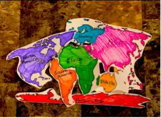

Students use paper continent models and stop-motion animation to represent plate movement over geologic time. The activity requires students to use evidence about plate motion to construct and explain a possible future continental configuration.
The complete unit plan and an example lesson plan are provided in Supplemental Materials A and B, respectively.
Why Start with What Students Think?
One of the most useful changes I made was to stop treating students' initial ideas as something to correct only after instruction. Instead, I began treating those ideas as the starting point for instruction. At the beginning of the unit, students complete a short diagnostic ConcepTest and examine global patterns of earthquakes and volcanic activity. Before providing explanations, I ask students to describe what they notice and explain what they think might account for those patterns. Questions such as these help make their thinking visible:
- Where are earthquakes concentrated?
- Where are volcanoes concentrated?
- What patterns do you notice?
- What do you think causes those patterns?
- What do you think is happening beneath Earth's surface?
The purpose is not to grade students' initial answers. It is to find out what they are thinking. ConcepTests are particularly useful because they turn questioning into an instructional routine rather than a simple right-or-wrong assessment. I use students' responses to decide what needs additional attention and to generate discussion. If many students select the same incorrect explanation, I do not simply provide the correct answer. Instead, I ask students to explain their reasoning, compare their ideas with those of their classmates, and look for evidence that can help distinguish among competing explanations. This approach also gives students a reason to revisit their thinking. An idea they expressed at the beginning of the unit can become a question to investigate during the Explore phase and something to reconsider when they construct their final model. The routine is simple: Ask → Think → Discuss → Explain → Revisit
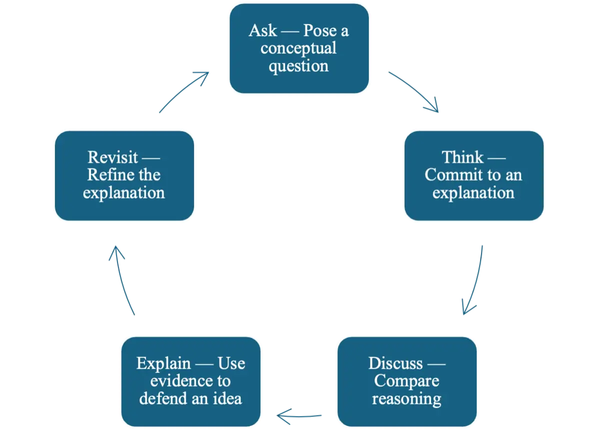
Students move through a recurring cycle of asking a conceptual question, committing to an initial explanation, discussing and comparing ideas, using evidence to explain their reasoning, and revisiting and refining their explanations.
For instructors who would like to incorporate ConcepTests into their own courses, NAGT's Teach the Earth collection,ConcepTest: Pacific Plate Motion, provides examples that can be adapted for introductory geoscience instruction, including questions addressing plate tectonics.
Explore: Let Students See the Earth Move
Once students have made their initial ideas visible, we move into guided exploration. One of the challenges of teaching plate tectonics is that students must reason about processes they cannot directly observe. Interactive visualizations can make these processes more accessible by allowing students to manipulate representations, examine spatial relationships, and connect surface features with processes occurring beneath Earth's surface.
One resource I use is the Earthquakes and Volcanoes Interactive, which allows students to explore relationships between earthquakes, volcanoes, plate boundaries, and other tectonic features. I pair the visualization with questions such as:
- What patterns do you notice?
- Which features tend to occur together?
- Where are the patterns strongest?
- What might explain those patterns?
- What additional evidence would you need to test your explanation?
The goal is to shift students from simply viewing a map to using the visualization as evidence.
I also use Mountain Maker, Earth Shaker, an interactive that allows students to manipulate tectonic plates and observe changes associated with different types of plate interactions. Students can compare what happens when plates move apart, collide, or slide past one another and consider how those interactions produce different surface features.
During these activities, I try to resist the temptation to explain everything immediately. Instead, I use students' observations to guide the conversation. For example, I might ask:
"You said that mountains form where plates collide. What do you think is happening below the mountain?"
Or:
"If plates are moving continuously, what would the boundary look like over millions of years?"
Questions like these encourage students to connect what they observe at Earth's surface with processes occurring below the surface and across geologic time.
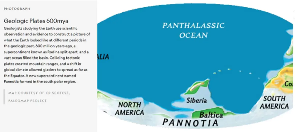
This reconstruction of Earth's tectonic plates approximately 600 million years ago provides a visual representation of how continental configurations change through geologic time. Images such as this can help students connect present-day plate motion with the changing spatial arrangement of continents.
Source: Map courtesy of C. R. Scotese, PaleoMap Project (Earth's Shifting Tectonic Plates)
Connecting Evidence to Explanation
The Explore phase can also incorporate short video case studies and visualizations of mid-ocean ridges, plate boundaries, and seafloor processes. Google Earth and other map-based tools can be used when instructors want students to investigate plate configurations and geographic patterns in greater detail.
The particular technology matters less than how students use it. I try to follow a simple rule: I do not show a visualization simply because it is interesting. I give students something to investigate. For example, rather than displaying an earthquake map and explaining its distribution myself, I might ask students to identify three patterns and propose an explanation for each. We then compare their explanations and consider which are supported by the available evidence.
This approach helps students move beyond memorizing the names of plate boundaries. The goal becomes asking and answering more meaningful questions: What do we observe? What might explain it? What evidence supports that explanation? That shift from viewing a visualization to reasoning with one is central to the Explore phase.
Model: Pangea Ultima
The culminating activity is the part of the unit that generated the greatest sustained engagement. Over three class sessions, students work in pairs to construct a stop-motion model representing continental movement and one scientifically plausible future supercontinent approximately 250 million years from now. To build their models, students draw on tectonic maps, information about plate motion, evidence from past continental configurations, and their developing understanding of plate interactions.
The activity begins by asking students to reconstruct past continental configurations. Working backward from evidence gives students an opportunity to think about how Earth's surface has changed before asking them to consider how it might change in the future. Students then use information about present-day plate motion to make decisions about the direction and relative movement of continents. As they construct their models, I ask questions such as:
- Which plates are moving toward one another?
- Which are moving apart?
- Where might subduction occur?
- Where might new oceanic crust form?
- Where might continental collision produce mountain building?
- How might these processes affect the future arrangement of the continents?
Students label, color, and cut out continent shapes and arrange them in their present-day positions. They then move the continent pieces in small increments, capturing images as they go, and combine the images into a stop-motion animation. This iterative process allows students to represent continental movement frame by frame and visualize changes that would otherwise be impossible to observe directly. The final product represents one possible sequence of continental movement culminating in a future Pangea Ultima configuration. A sample stop-motion movie from the activity can be viewed here:
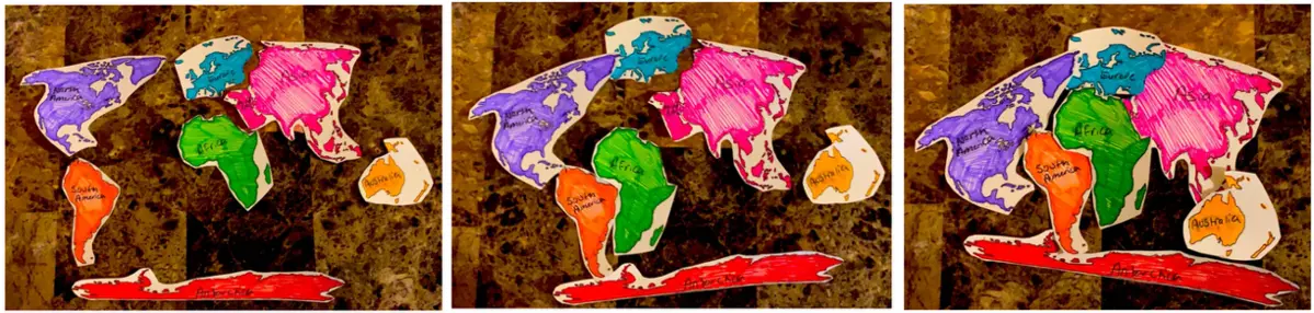
Three still frames from a student-created stop-motion model illustrate the transition from the present-day continental configuration through an intermediate stage to one possible future supercontinent configuration. The sequence emphasizes that the activity is a model-based exploration of possible future change, not a prediction of Earth's exact configuration.
The important word here is possible
The goal is not to suggest that students can predict Earth's exact configuration 250 million years from now. Instead, the activity asks students to use current geologic evidence, present-day plate motions, and stated assumptions to construct a defensible model of how Earth's surface might change. This distinction creates a useful opportunity to discuss scientific modeling. Models are not exact copies of reality. They are representations constructed for particular purposes using available evidence and assumptions.
As students work, I ask questions that shift the focus from simply producing an animation to using a model to communicate scientific reasoning:
- What evidence supports the direction in which you are moving this continent?
- What type of plate interaction might occur as these continents converge?
- What geological features might develop as a result?
- What assumptions are you making about future plate movement?
- How does your model compare with what you know about present-day plate boundaries?
Making Student Thinking Visible
One of the most valuable things I noticed during the activity was that students often revealed more about their thinking while constructing and explaining their models than they had during conventional questioning. A student might correctly identify a plate boundary on a map but then move a continent in an inconsistent direction when building the model. Another student might understand that two continents are moving toward one another but struggle to visualize what happens at the boundary over millions of years.
These moments became instructional opportunities. When students encountered difficulties with directionality, spatial scale, or interpreting tectonic maps, I used targeted prompts and structured pauses to help them reconsider their decisions. Students also compared their developing models with those of their classmates and explained why they had made particular choices. The modeling process therefore served two purposes: it gave students an opportunity to apply and communicate their understanding, and it gave me a window into their thinking. Rather than seeing only a final answer, I could observe the decisions students made as they constructed their models and ask them to explain the evidence and assumptions behind those decisions.
The activity also helped students connect ideas that are often taught separately. Instead of treating plate boundaries, continental drift, mountain building, and geologic time as isolated topics, students had to consider how these processes interact to produce a changing Earth. The complete Pangea Ultima Lab, including student instructions and the assessment rubric, is provided as Supplemental Material C. The activity can be adapted for undergraduate or secondary Earth science classrooms and scaled according to available class time and technology.
Use Assessment to Decide What Happens Next
Assessment in this unit is woven into instruction rather than reserved for the end. In addition to the initial and later ConcepTests, I use hinge-point questions, peer explanations, brief reflective writing, and observations of students as they construct their models. The question I ask is not simply, "Did students get the answer right?" but "What does this response tell me about what I should do next?"
If students demonstrate a sound understanding, I can move forward. If their responses reveal a common difficulty or alternative explanation, I can pause, introduce another representation, ask students to compare explanations, or revisit an earlier idea. In this way, assessment becomes part of the instructional process rather than a separate event at the end of a lesson. This use of formative assessment is consistent with the broader principle of using evidence of student understanding to inform subsequent instruction (Black & William, 1998).
I also found that ideas students appeared to understand in one context did not always transfer immediately to another. A student might explain a concept accurately during a class discussion and then make a different choice while constructing a model. Rather than treating this as simply an incorrect answer, I viewed it as useful information about where additional support or application was needed.
For example, if a student correctly identified a convergent boundary but moved the associated continents in an inconsistent direction during the modeling activity, I could ask the student to return to the tectonic map, explain the direction of motion, and reconsider the model. The assessment was therefore embedded in the activity itself.
What Worked and What I Would Change
The most successful aspect of the unit was the progression from students' initial ideas to evidence-based exploration and, finally, to modeling. The Elicit phase gave me information about students' starting points. The Explore phase gave students opportunities to investigate those ideas using evidence and visual representations. The Model phase required them to bring multiple ideas together and use them to construct and explain a representation of a changing Earth. Several elements were particularly useful.
Visualization. Dynamic representations helped students reason about processes that occur across spatial and temporal scales that are difficult to experience directly. Visualizations gave students something they could examine and discuss rather than requiring them to rely entirely on static diagrams or verbal descriptions.
Student-generated models. The Pangea Ultima activity required students to make decisions rather than simply reproduce an instructor-provided diagram. Their choices made aspects of their reasoning visible and gave me opportunities to ask about the evidence and assumptions behind their models.
Formative assessment. ConcepTests and hinge-point questions provided quick information that I could use to determine whether to move forward, revisit an idea, or provide another representation.
Peer explanation. Asking students to explain their reasoning to classmates often surfaced uncertainties that were not immediately apparent during whole-class discussion. Explaining a decision also required students to make their reasoning explicit rather than simply selecting an answer.
What Needed Tweaking
The activity also taught me that inquiry requires scaffolding. Students sometimes struggled with the direction of plate movement, the enormous spatial scale of tectonic systems, and the continuity of movement across geologic time. Some also needed additional support when interpreting tectonic maps.
In response, I added more explicit prompts about directionality and scale and incorporated structured pauses during which students compared their developing models and explained their decisions. These pauses gave students opportunities to identify inconsistencies before completing their animations and gave me opportunities to intervene when a misunderstanding was affecting the model.
The lesson for me was simple. Giving students an inquiry task does not mean leaving them on their own. Productive inquiry requires carefully chosen questions, appropriate representations, opportunities for students to explain their thinking, and timely instructor support.
That balance, providing enough structure to support productive reasoning while leaving enough room for students to make meaningful decisions, is what made the modeling activity work.
A Few Misconceptions Worth Watching For
The unit does not attempt to address every misconception about plate tectonics. However, several recurring ideas are useful to watch for because they can become productive starting points for discussion and model revision.
"A plate boundary is a line." Students may represent boundaries as narrow lines rather than as zones of complex interaction. Cross-sectional diagrams and interactive representations can help students connect the map view with what is happening beneath Earth's surface.
"Magma is a continuous layer beneath Earth's surface." Students may imagine that magma exists everywhere beneath the crust and simply rises wherever a volcano occurs. Ask students where melting occurs, what conditions are required for partial melting, and how those conditions vary among tectonic settings.
"Mountains simply sit on top of plates." Students may recognize that mountains are associated with plate convergence without understanding the deformation, crustal thickening, and other processes involved in mountain building. Asking students what is happening beneath a mountain can help move the discussion from surface features to underlying processes.
"Continents suddenly move." Students may understand that continents move but have difficulty connecting that movement with continuous processes operating over millions of years. The stop-motion model provides a concrete way to represent gradual movement and discuss the relationship between small changes and large-scale patterns.
These ideas are useful not because instructors need to identify and eliminate every misconception, but because they provide entry points for productive questions. When a student's explanation differs from the scientific model, that explanation can become something to investigate, test against evidence, and revisit.
Adapting the Unit to Your Classroom
You do not need six class sessions to use this approach. The sequence is intentionally modular. If you have one class period, use the Elicit and Explore components:
- Begin with a ConcepTest.
- Have students examine earthquake and volcano patterns.
- Ask students to identify patterns and propose explanations.
- Use an interactive visualization to investigate those explanations.
If you have two or three class periods, add guided exploration and a short modeling task. Students might construct a simplified representation of a plate boundary or continental movement. Finally, if you have several class periods, use the complete sequence and devote the final sessions to the Pangea Ultima model. Google Earth or GIS-based resources can be incorporated for students who are ready for more detailed spatial analysis.
The approach can also be adapted to different levels of preparation. In high school classrooms, partially completed maps, guided questions, vocabulary support, and model templates can provide additional scaffolding while preserving the inquiry structure. In advanced undergraduate courses, students can be asked to use more evidence to justify their models, compare alternative future-supercontinent configurations, or explain the geologic consequences of their proposed plate interactions. The central structure remains the same: Elicit → Explore → Model.
Connecting the Activity to NGSS and the Nature of Science
The activities connect naturally with the Next Generation Science Standards' Earth and Space Science disciplinary core ideas, particularly ESS2.A: Earth Materials and Systems and ESS2.B: Plate Tectonics and Large-Scale System Interactions (NGSS Lead States, 2013). The sequence also engages students in science and engineering practices such as developing and using models, analyzing and interpreting data, and constructing explanations from evidence.
The sequence provides opportunities to reinforce an important Nature of Science idea as well: scientific explanations and models are developed, tested, refined, and sometimes revised in light of evidence. This becomes especially visible when students construct a model, recognize that an initial representation does not adequately account for the available evidence, and revise it.
For instructors who explicitly teach the historical development of continental drift and plate tectonics, the Pangea Ultima activity can also provide a bridge between historical evidence and modern scientific modeling. Students can consider how observations contribute to scientific explanations and how new evidence can lead scientists to revise the mechanisms used to explain those observations.
A Final Takeaway
Teaching plate tectonics does not have to mean giving students increasingly detailed diagrams until they can reproduce the correct one. For me, the more useful shift was to ask students to show me what they think, investigate evidence, and then use that evidence to build something.
The Elicit → Explore → Model sequence provides a simple structure for doing that. The Pangea Ultima activity is particularly valuable because it brings together spatial reasoning, plate motion, geologic time, and causal explanations in a single model. Just as importantly, the modeling process gives instructors opportunities to see student thinking that may remain hidden during conventional questioning.
The goal is not to eliminate every misconception in six class sessions. It is to create repeated opportunities for students to ask questions, examine evidence, explain their thinking, revise their models, and connect multiple pieces of evidence to understand Earth's dynamic systems. That is the kind of scientific reasoning we want students to carry with them beyond the plate-tectonics unit.
References
Black, P., & Wiliam, D. (1998). Assessment and classroom learning. Assessment in Education: Principles, Policy & Practice, 5(1), 7–74.
Clark, S. K., Libarkin, J. C., Kortz, K. M., & Jordan, S. C. (2011). Alternative conceptions of plate tectonics held by nonscience undergraduates. Journal of Geoscience Education, 59(4), 251–262. https://doi.org/10.5408/1.3651696
Dahl, J., Anderson, S. W., & Libarkin, J. C. (2005). Digging into Earth science: Alternative conceptions. Journal of Geoscience Education, 53(2), 180–192.
Libarkin, J. C., & Anderson, S. W. (2005). Assessment of learning in entry-level geoscience courses: Results from the Geoscience Concept Inventory. Journal of Geoscience Education, 53(4), 394–401. https://doi.org/10.5408/1089-9995-53.4.394
McConnell, D. A., Steer, D. N., Owens, K. D., Knott, J. R., Van Horn, S., Borowski, W., Dick, J., Foos, A., Malone,
M., McGrew, H., Greer, L., & Heaney, P. J. (2006). Using ConcepTests to assess and improve student conceptual understanding in introductory geoscience courses. Journal of Geoscience Education, 54(1), 61–68. https://doi.org/10.5408/1089-9995-54.1.61
NGSS Lead States. (2013). Next Generation Science Standards: For states, by states. The National Academies Press. https://doi.org/10.17226/18290
Supplemental Materials
- Supplemental Materials (Microsoft Word 2007 (.docx) 277kB Oct15 26)
Comment? Start the discussion about Making Plate Tectonics Visible: An Inquiry-Based Modeling Approach